Washington is currently considering an increase in federal infrastructure spending, and the word swirling around the debate is “streamlining.”1 Specifically, the Trump administration wants to streamline the environmental review process required under the National Environmental Policy Act (NEPA) for major infrastructure projects.2
The Oxford English Dictionary defines streamline as to “make (an organization or system) more efficient and effective by employing faster or simpler working methods.”3 As a matter of political messaging, the administration’s use of this word is rather brilliant; few people are likely to oppose bureaucratic streamlining. After all, bureaucracies are not known for being lithe. Yet this messaging turns out to be sophistry.
The president is conjuring up images of red tape, lumbering civil servants, and a Washington leviathan that saps the U.S. economy of dynamism, all to hide his administration’s true intent: to eviscerate foundational environmental laws that protect natural habitats, clean air and water, and the quality of life for local communities.4
NEPA is fundamentally about community empowerment and democratic decision-making, both of which require people to have access to information. When a state or local government wants to use federal funds to build something, it must first complete an environmental review. 5 This review is intended to discover any significant individual or cumulative environmental impacts that the project would create.6 These impacts could include anything from habitat fragmentation and species loss to adverse social, economic, health, or cultural effects on low-income individuals or communities of color.7
As part of the review process, the public has the right to comment on the proposed project. Before a project can receive federal approval, the state or local government sponsor must address these comments and, where possible, make changes to mitigate community and environmental impacts. In short, NEPA is the sunshine that illuminates governmental planning, allowing the public to understand and shape proposed projects before a single shovel goes into the ground.
Importantly, the federal government did not stumble into requiring environmental review. NEPA is not the result of thoughtless regulatory accretion. The law represents a hard-fought political victory decades in the making. Congress enacted NEPA in 1969 because the status quo of developing projects behind closed doors and without careful study had produced truly dreadful results.8
Unfortunately, this victory is under assault like never before. In the place of thoughtful study and robust public participation, NEPA opponents are promising drastic changes in service of one thing: speed. “Better, faster, cheaper” is the prevailing mantra. The problem with this approach to infrastructure development is that shaving a few months off the project review timeline can result in facilities that produce real harm for decades, all at a steep cost to taxpayers.
NEPA helps produce better projects
At its core, NEPA is a procedural statute that requires project sponsors to work through certain steps before construction can begin. Unlike other environmental laws such as the Clean Air Act and the Clean Water Act, which focus public attention on specific outcomes, it can be hard to rally interest around a procedural requirement. Activists rarely hold up placards emblazoned with slogans like “protect the process!” For this reason, it is critical to tell NEPA’s story through concrete examples.
This issue brief highlights two projects—the Everglades Parkway and the Charlotte Blue Line light rail extension—that offer powerful examples of how undertaking an environmental review can produce fundamentally better infrastructure with fewer harmful impacts.
The Everglades Parkway
Following the passage of the Federal-Aid Highway Act of 1956, the United States began a national program of highway construction to facilitate more efficient connections between metropolitan areas and provide farmers with better access to local markets.9 The act authorized the construction of a 41,000-mile system.10 In 1968, Congress passed another highway bill to expand the interstate system by an additional 1,500 miles.11 The legislation included an authorization to extend Interstate 75 (I-75) south and east from Fort Myers on the Gulf Coast to an area west of Fort Lauderdale on the Atlantic Coast. 12 The 114-mile extension would become known as the Everglades Parkway.
In 1969, the Florida Department of Transportation (FDOT) began to study alternative routes. Unlike the planning for earlier interstate segments, FDOT was required to comply with NEPA. As a result of the procedural requirements that NEPA set forth, the I-75 extension included numerous design elements tailored to minimize impacts on the natural environment. Importantly, none of these design elements undermined the original goal of the project: to construct a limited-access, four-lane, divided highway that would connect Gulf and Atlantic Coast population centers, providing increased travel speeds and reduced travel times.
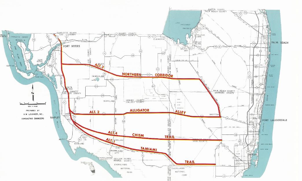
ALTERNATIVE PARKWAY ROUTES
Photo courtesy of the Florida Department of Transportation.
Large infrastructure projects such as the I-75 extension present states with many technical challenges. Engineers must determine everything from pavement type and interchange design to the sharpness of curves and how to prevent rainwater from forming unsafe pools on the roadway. These challenges share a common thread: They are all related to the design of the roadway. Prior to NEPA, engineers focused narrowly on how to design a facility as opposed to how that facility would affect the surrounding community or natural environment. Part of NEPA’s value is that it requires planners and engineers to widen the aperture of concern. Environmental review necessitates that state and local governments solve the engineering puzzle in a way that minimizes the negative spillover that often accompanies major infrastructure projects.
Environmental review minimizes negative ecological impacts
The environmental review produced by FDOT for the Everglades Parkway states clearly—albeit in rather subdued bureaucratic language—the damage that new highway facilities can produce: “Evaluation has revealed that some existing transportation systems, including highways, permit or encourage development in areas ill-suited for it from a regional resource standpoint.”13 In the case of the Everglades Parkway, the problem of this induced development was of particular concern.
In order to connect Fort Myers with Fort Lauderdale, FDOT knew that the I-75 extension would have to cut through highly sensitive areas, including both the Big Cyprus and Everglades watersheds. Taken together, these two watersheds cover thousands of square miles and provide vital habitat to many different species. The state described South Florida and its unique watersheds as a “rare and endangered complex.”14 Additionally, FDOT planners noted that these areas were “vital to [the] maintenance of groundwater supplies for areas already urbanized.”15 In short, a poorly designed highway could unleash land development that would threaten critical habitats and essential drinking water supplies.
In response, FDOT developed a design that achieved the goal of an efficient connection between the coasts while reducing the harm to wildlife and clamping down on unwanted development. FDOT states that the goal of the extension was to provide “fast, safe, and efficient transportation across South Florida, not to improve transportation and accessibility for the intermediate land areas.”16
To reduce the impacts on animal populations, such as roadkill, the final design included 24 wildlife underpasses and fencing along 40 miles of the route.17 In addition, FDOT purchased local access rights and eliminated frontage roads. To understand why this decision was so important, it helps to step back and look at the role of frontage roads in transportation.
On a basic level, land only has value if it can be used; and land can only be used if it can be accessed. A real estate developer that builds houses on inaccessible land will not be in business for very long. The most common form of land access is provided by roadways, which exist on a design spectrum. On one end of this spectrum are roadways that provide low travel speeds and a high degree of access. For example, local neighborhood streets typically have a driveway that connects each house to the road. Vehicles on these local roads travel slowly to safely accommodate cars pulling in and out of traffic. On the other end of the spectrum, highways provide limited access and high travel speeds. For instance, interstate highways are grade-separate and limited-access, meaning that crossing roadways must pass over or under and that vehicles are only able to enter or exit at interchanges that are spaced far apart.18 The limited-access design is both highly efficient and safe. On-ramps allow cars to merge safely into the traffic stream in a way that a vehicle pulling out from a driveway onto an interstate could not.
Thus, building an interstate means limiting highway access for landowners who live adjacent to the highway. After all, building an interchange to serve every landowner would be both prohibitively expensive and defeat the entire purpose of an interstate. Depending on state law, however, landowners may have certain access rights. In Florida, the I-75 extension converted the existing State Route 83—also known as Alligator Alley—which provided adjacent land owners with certain access rights. FDOT stated in its review that, “Presently, uncontrolled access along Alligator Alley enhances the saleability of subdivision lots with little else to recommend them.”19
This left FDOT with a choice to either build a frontage road that would run parallel to the interstate and provide the access to which landowners were entitled or buy out those access rights. By building a frontage road, Florida would be providing landowners with the access necessary for future commercial and residential development. However, in order to limit future growth along the corridor to the greatest extent possible, FDOT chose to purchase local access rights instead of building a frontage road.
Finally, FDOT wanted to improve the flow of fresh water through the Big Cyprus and Everglades wetlands. The ecology of South Florida is based on a large volume of water flowing south from Lake Okeechobee, through the wetlands, and into the Gulf of Mexico. The flow consists of a massive, shallow, slow-moving sheet as opposed to a river contained within a defined channel. Decades of agricultural and urban development—including the construction of the original State Route 83—substantially disrupted this flow. Through the NEPA process, FDOT recognized that the Everglades Parkway project represented an opportunity to improve the natural flow.
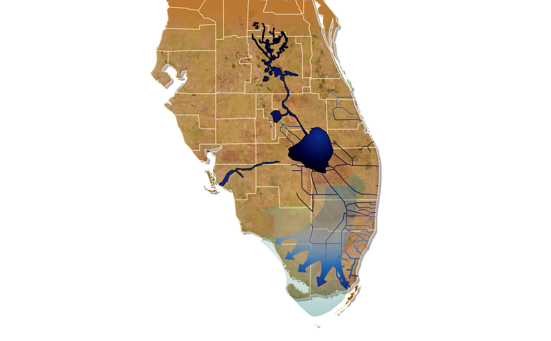
IMPROVED EVERGLADES FLOW
Photo courtesy of the U.S. Department of the Interior.
Improving flow involved several design modifications. According to FDOT design policy at the time, highways were required to provide at least 100 feet of land between the edge of the roadway and any adjacent body of water.20 This requirement was intended to reduce the risk of passengers drowning in the event that a driver loses control of a vehicle. In effect, the 100-foot buffer provided a chance for a driver to slow the vehicle and regain control, hopefully avoiding entering the water. In the case of the Everglades Parkway, complying with this requirement would have meant draining additional wetland on either side, further impairing critical habitats and the sheet flow of fresh water. Instead, FDOT chose to waive this policy and add a cable barrier where necessary. The cable barrier would stop wayward vehicles before they reached the water.21
FDOT’s final significant modification dealt with the channels running parallel to the highway on either side as well as the connections spaced at regular intervals that connected the channels on the north and south side of the highway. Experience with the channels along the original State Route 83 showed that the state needed to both modify their depth and regularly remove aquatic vegetation that could reduce sheet flows by as much as 90 percent.22 FDOT also scheduled construction activity to avoid the heaviest seasonal rains. By adjusting the sequence and timing of work, the state was able to significantly reduce sedimentation—rainwater carrying dirt, rocks, and other loose debris from the construction site into the wetlands.23
The environmental review process provided FDOT with the information necessary to make smart and effective changes to the design, construction, and maintenance of the Everglades Parkway, all with an eye toward reducing harmful impacts on the surrounding ecosystem. Far from being a burden, NEPA brought forward the technical expertise of scientists across numerous fields to help the state build a fundamentally better, more sustainable facility that continues to provide benefits to this day.
The Charlotte Blue Line light rail extension
In Charlotte, North Carolina, NEPA provided the Charlotte Area Transit System (CATS) with a process to identify the most appropriate route and transit technology combination as well as other design elements and construction practices to meet local mobility needs while minimizing social and ecological impacts.
The environmental review process seeks to minimize negative project impacts on both macro and micro scales. In other words, NEPA requires project sponsors to ask two related questions: First, what should be built? And second, how should it be built? This means that sponsors must focus on mitigating project impacts from the outset rather than simply polishing any rough edges at the end.
The NEPA process begins with the requirement that state and local government project sponsors clearly define the transportation challenge that the proposed project will resolve. This is known as the statement of purpose and need. This statement is significant because it serves as the basis for another major element known as an alternatives analysis. Essentially, the sponsor must analyze different options for meeting the defined need, including a no-build option.
The alternatives analysis process is critical because it answers the question of what should be built to meet the defined local need. The truth is that all infrastructure projects produce environmental impacts. Each project alternative involves tradeoffs to both transportation performance and environmental impacts. By considering multiple project options, the state or local government sponsor is able to find a preferred alternative that delivers the optimal combination of performance and mitigation.
For a public transportation project such as the Charlotte Blue Line, the range of alternatives could include different route and transit technology combinations. One alternative could be a light rail line operating within a dedicated right of way. Another alternative could be a rapid bus line operating in mixed traffic. Each transportation technology and route combination would offer a different level of performance and impose a different level of community and ecological impact.
For instance, assembling the light rail right of way could involve substantial eminent domain of historic homes, while the rapid bus could use existing roadways. At the same time, the light rail line would carry more passengers and use clean renewable energy to power its trains, while the rapid bus would carry fewer passengers and would likely rely on diesel or natural gas.
After selecting a preferred alternative, the state or local government sponsor carries out additional engineering and design work. This stage of the process allows the sponsor to revise and refine the design in order to achieve additional mitigation and performance improvements. For instance, a sponsor may decide to grade separate a planned light rail line where it crosses a major arterial roadway. By routing the train above or below the intersection, vehicles would not be forced to sit and idle as trains passed by dozens of times each day in both directions. The Charlotte metropolitan area is one of the fastest-growing and most economically dynamic regions in the United States. Since 1990, the area has grown from 1 million residents to its current population of more than 2.3 million.24 With growth has come additional congestion. In response, CATS has expanded public transportation service, including the construction of light rail transit.
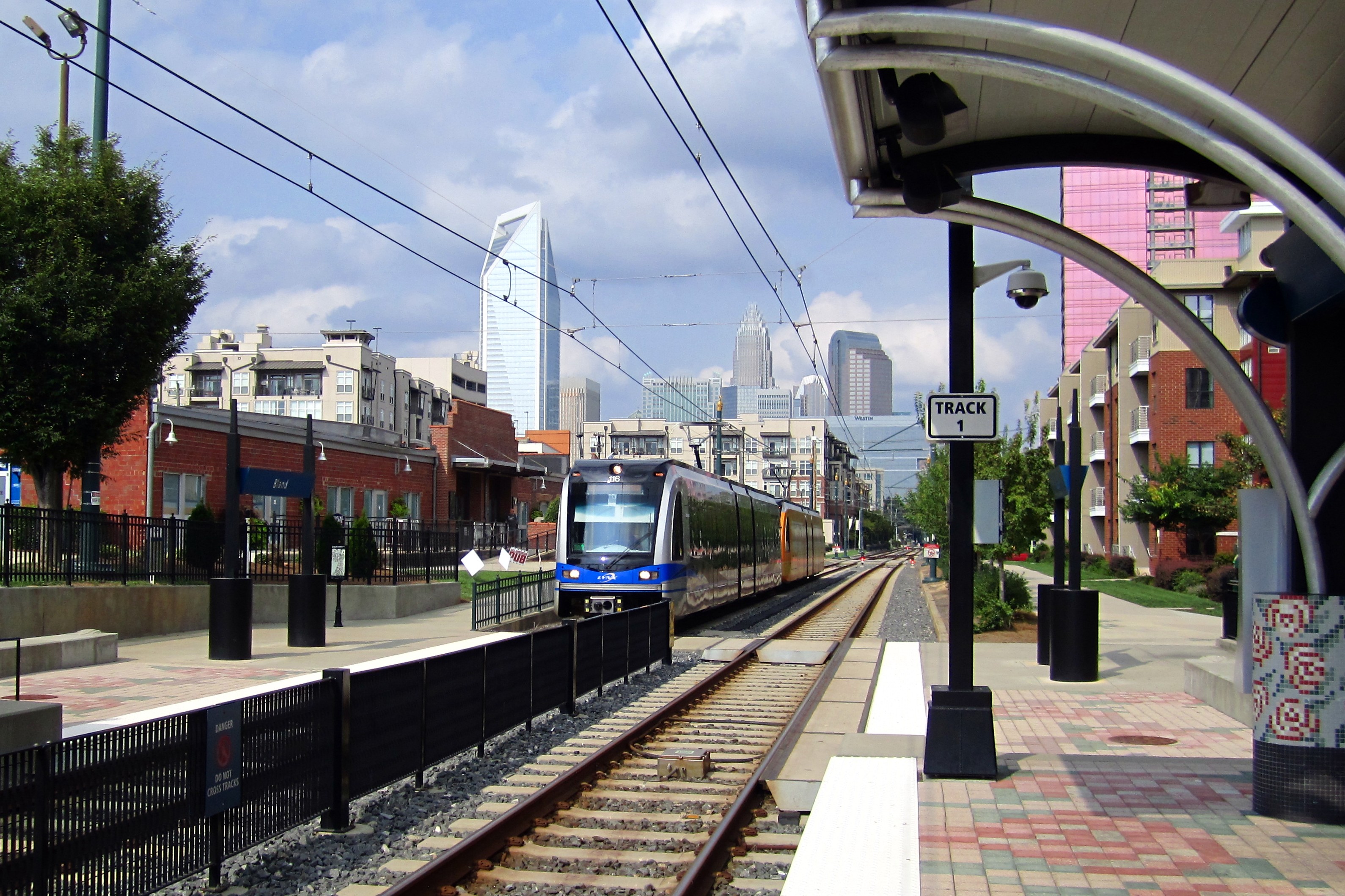
BLAND STREET STATION
Photo available under CC BY-SA 3.0 license (credit: Prasit Frazee).
For local leaders, light rail transit not only provides mobility but also advances regional development goals. In 1994, the city of Charlotte adopted the first of several land use plans that called for focusing growth within the downtown and along five corridors extending out from the city center.25 Over the years, Charlotte has refined its vision for growth to include a focus on building more mixed-use, pedestrian-friendly neighborhoods around transit stations in order to “minimize motor vehicle trips.”26
In 2007, after years of planning and building political support, CATS opened its first light rail segment known as the LYNX Blue Line, which extends south 9.6 miles from downtown Charlotte.27 Within the first year of service, ridership doubled the preconstruction forecast, providing more than 18,000 weekday trips.28
Following the success of the first segment, CATS and local elected officials pushed to extend the Blue Line 9.4 miles northeast to the University of North Carolina at Charlotte.29 Upon completion in 2018, the Blue Line extension will provide more residents with a safe, affordable, and efficient alternative to driving. Additionally, the extension will support increased residential and commercial density along the corridor, as called for in the city’s updated land use plan.30
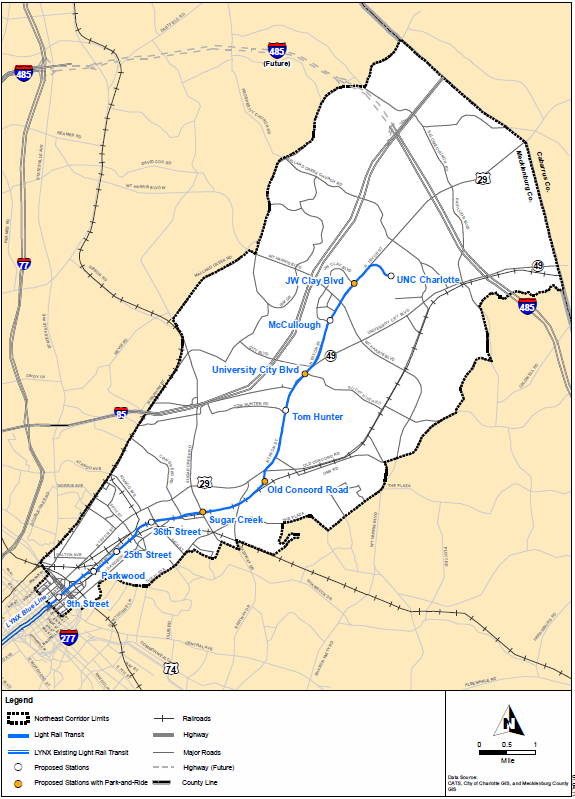
BLUE LINE EXTENSION CORRIDOR MAP
Photo courtesy of the Charlotte Area Transit System.
Before deciding to extend the Blue Line, however, CATS conducted a full alternatives analysis as required under NEPA. This included a review of a wide range of options, including rapid bus, light rail, streetcars, and commuter rail. From this broad set of possibilities, CATS narrowed its analysis to those options that were not “fatally flawed from an engineering or environmental perspective or would be unlikely to meet project goals and objectives.”31
CATS conducted detailed analysis of several rapid bus and light rail alternatives as well as one streetcar option.32 The analysis determined that “The BRT [bus rapid transit] alternatives would serve existing land use patterns better than the light rail alternatives, but light rail would have more potential to support the desired shape of future development.”33 Thus, CATS used the transportation and land use goals established by the city of Charlotte to inform its NEPA purpose and need statement, which—along with other factors such as cost and ridership—served as the basis for analyzing project alternatives.
Initially, CATS selected a light rail alternative that would have included 13 stations, extending 10.6 miles northeast from downtown. However, due to the severe economic slowdown created by the Great Recession, CATS decided to reduce project costs by cutting two stations, scaling back structured parking, and shortening the line by 1.2 miles.34 In 2011, CATS adopted the revised light rail design, finding that it caused “the least damage to the biological and physical environment, while best protecting, preserving and enhancing historic, cultural and natural resources.”35
As intended, the NEPA alternatives analysis process allowed CATS to answer the macro question of what project should be built to advance the defined local purpose and need. Next, CATS used NEPA to answer the micro question of how to deliver the project in a sustainable manner.
As part of the review process, CATS conducted a detailed traffic impact analysis of 55 intersections along the rail route in order to identify where the line should be grade-separated from existing roadways.36 For urban rail lines, grade separations affect safety, train run times, cost, intersection delays, and traffic spillover to adjacent intersections. The CATS analysis determined that the extension should include grade separations at all major intersections, railroad crossings, and entry and exit points for U.S. Route 29.37 In total, the Blue Line extension includes 11 new grade separations.38 For instance, the inclusion of a grade separation of the light rail line with 36th Street will allow intersection performance—known in traffic engineering terms as “intersection level of service”—to remain unchanged at the intersection of 36th and North Davidson.39
To understand the importance of including multiple grade separations, one must consider how the Blue Line extension might have looked if CATS engineers had focused narrowly on delivering fast train run times in the most cost-effective manner possible. For starters, grade separations are expensive compared with standard at-grade crossings, which only require the installation of a flashing gate. CATS could have chosen to construct the line at grade, granting trains travel priority and forcing vehicles to wait throughout the day. This approach would have saved the agency money without sacrificing train run times.
However, while at-grade crossings may save the project sponsor money in the short run, they increase roadway delay and air pollution from idling vehicles traveling within the rail corridor. As a result, the Charlotte region would suffer from reduced economic productivity and more polluted air. Fortunately, NEPA requires project sponsors to take into account how new facilities will affect safety, air quality, and roadway conditions, among other measures of community and environmental impact.
Safety is another core community impact under NEPA. This means that project sponsors must consider how a new facility may increase injuries and fatalities. A portion of the Blue Line will travel along roadways with numerous cross streets that are not signalized, meaning that pedestrian and vehicle movements are not controlled by traffic lights but by stop signs and individuals’ discretion. For roadways with few pedestrians and low traffic volumes, this approach works well. However, the presence of a new light rail line would increase development, travel demand, and pedestrian use. In response, CATS added traffic lights to fully control vehicle and pedestrian movements along U.S. Route 29, Orr Road, Arrowhead Drive, Owen Boulevard, Orchard Trace Lane, and at the University City Station. CATS notes in the environmental impact statement: “With light rail transit running in the median, safety requires traffic signals at all median openings.”40
Lastly, NEPA requires project sponsors to look at how a proposed facility will affect low-income communities and communities of color. This mandate stems from a sober and honest recognition that the location, scale, and design of infrastructure facilities have historically affected poor or otherwise disadvantaged neighborhoods at disproportionately high rates.41 In short, the choice to build an infrastructure project can itself be a form of discrimination. This impact may take the form of increased pollution and noise; increased household costs; reduced transportation access; or the loss of local businesses, housing, religious institutions, and social service providers through eminent domain, among other impacts.
As part of the environmental review process, CATS was required to conduct both a demographic analysis based on census data and an extensive inventory of community assets. The Blue Line extension will run through several neighborhoods in which residents are predominantly people of color with incomes that fall substantially below the area’s median household income.42
In order to construct the Blue Line, CATS had to acquire 90 acres of land, resulting in the displacement of 14 commercial or industrial businesses but no residential displacement.43 CATS found that none of the businesses “provide a unique or special service to a community of concern.”44 Therefore, the project’s most significant impact would be increased noise and vibrations. Eleven residential homes were expected to face a significant increase in noise or vibration. These impacts are considered adverse “due to the intensity of the impacts and disproportionate as no residential noise impacts would occur outside of minority and low-income communities of concern.”45 In response, CATS made changes to the project design to include the installation of “an automated friction modifier, noise barriers, sound insulation, specially-engineered track work and vibration isolation treatments.”46
Conclusion
The National Environmental Policy Act provides both the public and elected officials with access to the information necessary for informed decision-making, resulting in a more just, democratic, productive, and sustainable U.S. society. Opponents of NEPA want to curtail the flow of information in the name of expedience. On the surface, the prospect of building needed infrastructure projects more quickly may seem attractive. However, beyond the easy rhetoric of “better, faster, cheaper” lies an ugly reality of poorly conceived projects that produce long-lasting harms and ultimately cost our society and economy far more than any modest upfront savings. In short, the procedural requirements of NEPA yield real benefits. The time has come to recognize the service that environmental review provides and to allow the law to continue empowering local communities.
Kevin DeGood is the director of Infrastructure Policy at the Center for American Progress.