Introduction and summary
In November 2021, President Joe Biden signed into law the $1.2 trillion Infrastructure Investment and Jobs Act (IIJA), which provides historic investment across multiple infrastructure sectors, including more than $500 billion in new spending above baseline for surface transportation.1 Included within the surface transportation total is more than $114 billion in discretionary funding that will be distributed on a competitive basis by the U.S. Department of Transportation (DOT).2 This report lays out a novel and powerful framework for how the administration can ensure these discretionary funds maximize equity, sustainability, and inclusive economic growth by taking into consideration both project elements and the broader regional and statewide transportation context when making grant selection decisions.
While the IIJA contains more discretionary funding than previous federal infrastructure legislation, the competitive grant awards represent a modest share of total transportation spending in the bill. Most of the transportation funding will be distributed to states through formula programs. When spending formula funds, states are not required to demonstrate the social, environmental, or economic value of their projects. Beyond certain procedural and design requirements, states have total discretion, which often results in projects that run counter to progressive climate, equity, and economic goals. And unfortunately, many progressive policy reform proposals that would have significantly improved how states spend formula dollars were excluded from the final bill.
This raises an important question: How can DOT maximize the progressive impact of the discretionary grants provided by the IIJA? Stated differently, in the absence of structural policy reform, how can the tail of discretionary dollars wag the much larger formula dog? The answer is twofold. First, Secretary of Transportation Pete Buttigieg, working with the modal administrators, should prioritize projects that will reduce greenhouse gas emissions and automobile dependence, advance equitable access to jobs and essential services, and foster inclusive economic growth. Moreover, these funds should redress the ongoing harmful effects of discriminatory infrastructure projects, including the construction of certain portions of the interstate highway system that were targeted to displace communities of color.
Second, the secretary, when selecting among progressive alternatives, should prioritize those applications that advance a broader progressive regional or statewide transportation plan. Historically, DOT has assessed individual grant applications in isolation. The problem with this approach is that it fails to hold regions and states accountable for the choices they make with formula funds. For instance, a state may apply to DOT for funds to install a few electric vehicle (EV) charging stations while at the same time spending billions of formula dollars on a highway-widening project that will deepen auto dependence and dramatically increase harmful emissions.
Considering a grant application in light of the broader transportation context allows DOT to reward those regions and states that are advancing coherent progressive infrastructure programs.
Considering an application for EV charging infrastructure in isolation would miss the issue of magnitude as well as the incoherence of the statewide transportation plan. Whatever emissions reductions are achieved by adding new charge points would be overwhelmed by the additional greenhouse gas and criteria pollutants that result from the highway expansion. Yet, under the current approach to grantmaking, states are not penalized for advancing competitive and formula-funded projects that work at cross-purposes. This practice should end, beginning with the fiscal year 2022 grant award cycle. By comparison, considering a grant application in light of the broader transportation context allows DOT to reward those regions and states that are advancing coherent progressive infrastructure programs. Moreover, signaling to regions and states that the broader transportation context will factor into grant awards will induce project sponsors to develop more progressive and internally consistent plans.
The competitive grant funds in the IIJA provide DOT with an opportunity to shape the future of U.S. transportation and land use for decades to come. Failing to consider the larger regional or statewide transportation context would unnecessarily limit the progressive impact of discretionary grant funds provided by the IIJA. Additionally, there is no guarantee that the balance of power in Congress will align to allow progressive policy reforms to be included in the next reauthorization cycle beginning in 2026. Discretionary funds are a precious commodity, and it is imperative that DOT maximize the opportunity provided by the IIJA.
This report uses applications submitted to DOT’s Infrastructure for Rebuilding America (INFRA) grant program to demonstrate how such a process could work. It begins by reviewing the authorization language for the INFRA program to show that Secretary Buttigieg has the flexibility and discretion to fund progressive transportation projects and to request whatever information is necessary to make the best selections. Next, the report profiles three FY 2021 INFRA grant applications, including a complete streets project in Henderson, Nevada; a highway cap in Nashville, Tennessee; and a highway reconfiguration and street grid connectivity project in Dallas to demonstrate how DOT could account for the regional transportation context when assessing INFRA applications.
The framework put forward in this report argues that DOT should divide the application review process into a primary assessment, which would look at the specific project elements and goals, and a secondary assessment, which would look at the regional or statewide transportation context. DOT should prioritize discretionary grant funds for the most progressive project applications based on the primary review. If there are funds remaining after DOT has supported the most progressive projects, the department should use the secondary assessment of the regional or statewide context as the tiebreaker. The need for tiebreaking criteria is important since competitive programs almost always receive more applications than they can possibly fund. For instance, DOT received 157 applications requesting $6.8 billion in funding for the FY 2021 grant cycle, which is more than seven times the funding available through the INFRA program.3
Finally, this report argues that the project sponsor matters when assessing the regional or statewide context. For instance, when the project sponsor is a state department of transportation, both regional and statewide plans should be taken into consideration. The reason is that state DOTs own most major transportation assets, receive almost all federal surface transportation funds, and heavily influence investment priorities through the statewide planning process. In short, state DOTs largely control their own destiny and should bear full responsibility for their choices when applying for competitive grant awards from DOT. For substate project sponsors, including local governments and special purpose entities, the actions or plans put forward by the state DOT should carry substantially less weight unless the substate sponsor has committed funding to advance regressive and unsustainable projects.
INFRA grant program
The authorization for the INFRA grant program provides the secretary of transportation with substantial flexibility and discretion to advance sustainable and equitable transportation and land use by adding progressive social and environmental project selection criteria to the application-scoring framework. The program that DOT calls INFRA was authorized by Congress in 2015 as part of the Fixing America’s Surface Transportation (FAST) Act.4 Section 1105 of the FAST Act created a competitive grant program for “nationally significant freight and highway projects.”5 And while the underlying authorization has remained the same, the implementation of this program has shifted significantly with the change in presidential administration.
The FAST Act authorized seven goals for the program, including: 1) improving safety, efficiency, and reliability of the movement of freight and people; 2) generating regional or national economic benefits; 3) reducing highway congestion and bottlenecks; 4) improving connectivity between modes of freight; 5) enhancing transportation system resilience; 6) improving roadways vital to the energy sector; and 7) addressing the impact of population growth on the movement of people and freight.6
Under the Trump administration, the INFRA program focused competitive awards on four program objectives, including economic vitality, leveraging federal funds, innovation, and performance and accountability.7 These criteria broadly aligned with the Trump administration’s focus on pushing state and local project sponsors to raise more nonfederal funds and to use public-private partnerships as an alternative to traditional project delivery methods. As a result, the FY 2020 INFRA awards were concentrated on traditional highway projects for new capacity, interchange expansion, and greenfield bypasses, among other project categories.8
The Biden administration has substantially revised the Notice of Funding Opportunity (NOFO) for FY 2021 to reflect a progressive set of policy goals. Specifically, the NOFO states, “There are also two new program objectives that are incorporated into the merit evaluation process as described in Section E. These are Climate Change and Environmental Justice Impacts, and Racial Equity and Barriers to Opportunity.”9 The NOFO provides numerous examples of project elements that would qualify as addressing climate change, including a “modal shift in freight or passenger movement to reduce vehicle miles traveled” and “new or improved pedestrian/cycling connections or multi-modalism.”10 On racial equity, the NOFO looks at both the nature of the planning process to account for equitable involvement as well as project elements such as “investments that improve or newly connect underserved communities to proactively address barriers to opportunity or redress past inequities and barriers to opportunity.”11
Importantly, the FAST Act authorization for the INFRA program provides the secretary of transportation with unlimited discretion to define the types of information that a project sponsor must submit as part of the application process. Section 117 of Title 23 states that “[t]o be eligible for a grant under this section, an entity specified in paragraph (1) shall submit to the Secretary an application in such form, at such time, and containing such information as the Secretary determines is appropriate.”12 Thus, the secretary has the clear authority to require applicants to provide detailed information about the overall transportation plan and project context.
Given this authority, the secretary should require project sponsors to address the following questions within their applications regarding the regional or statewide transportation context and plans:
- What share of funding, inclusive of all sources, within the regional transportation improvement program (TIP) or statewide transportation improvement program (STIP) is dedicated to highway expansion?
- What share of funding, inclusive of all sources, within the TIP or STIP is dedicated to nonmotorized transportation facilities? To the extent that nonmotorized or complete street elements may be part of a larger project, the application should only include those funds reasonably attributed to the nonmotorized components and not the total project cost.
- Does the regional or statewide transportation plan include a performance measure for greenhouse gas emissions or total or per capita vehicle miles traveled?
- For substate applicants, what local funds, if any, have been formally committed to a limited-access highway-widening project within the region?
- What projects within the region or statewide are intended to reduce the mode share of single-occupant vehicle trips?
Boulder Highway in Henderson, Nevada
Henderson, Nevada, is a city of 332,000 located southeast of Las Vegas and within Clark County.13 There are several arterial highways within Henderson, including state Route 582, which is also known as the Boulder Highway. The Boulder Highway is a critical transportation link for the community. It runs from southeast to northwest, providing direct access to downtown Las Vegas.
The highway is a six-lane, at-grade facility designed to support traditional high-speed, high-capacity automobility. According to data from the Nevada Department of Transportation (NDOT), Boulder Highway is the fourth-busiest highway in Clark County.14 The bus lines that run along Boulder Highway carry more than 300,000 riders each month.15 Of this total, more than 5,000 riders connect to the public transit system by cycling.16 Unfortunately, the highway is also quite dangerous—especially for cyclists, pedestrians, and transit riders.
According to the city of Henderson, Boulder Highway suffers from two related problems. First, it is dangerous. In its application, Henderson states that “[t]he existing highway is wide, dark, and unwelcoming to non-vehicular traffic. The lack of streetlights, wide right-of-way, and infrequent crosswalks has made this stretch a challenge for bikers and pedestrians.”17Additionally, “[B]etween 2011 and 2016, 116 pedestrians were struck on Boulder Highway. Of these 116 people, 31 were killed, and 18 were seriously injured.18
116
Number of pedestrians struck on Boulder Highway between 2011 and 2016
Second, the existing highway design, with its heavy focus on high-speed automobility, doesn’t fit with the vision and goals Henderson has laid out for future development, transportation, and land use in the eastern portion of the city. According to Henderson’s most recent comprehensive plan:
Residents in Henderson, similar to the U.S. and neighboring cities, rely on personal vehicles as the primary source of transportation and do not often carpool. Public transportation use is particularly low in Henderson. Currently, most destinations (home, work, the grocery store, parks, etc.) are located separately and at a distance, meaning most residents are reliant on their cars. Commuting patterns mirror these trends. More than 80% of Henderson residents commute by themselves in a car to work, while only 2% of residents use public transportation, and 1% walk.19
The city’s top planning and development priority is to create “healthy, livable communities.”20 This means implementing policies and projects that “facilitate more compact, connected development, help residents increase their use of transit and expand opportunities for people to walk and bike to their destinations.”21 Local elected officials and planners correctly recognize that in order to shift transportation behavior, the underlying infrastructure must change to become more supportive of alternatives to driving to meet daily mobility needs. Additionally, the city needs to promote greater density and a more balanced mix of commercial and residential development, “which enables people to live closer to work and other community destinations they frequent.”22 Transforming Boulder Highway is a critical project to reduce major injuries and fatalities as well as advance this more balanced, sustainable, and healthy community vision.
Primary assessment
The city of Henderson has put forward an INFRA grant application to reconstruct a 7 1/2-mile segment of the highway, transforming it from its current auto-centric design into a multimodal boulevard with complete street features intended to support biking, walking, and transit users.23 The project has a total cost of $103 million.24 The transformation involves six major elements: 1) converting the travel lane closest to the curb into a bus-only lane; 2) adding a dedicated bike lane; 3) widening sidewalks, shortening pedestrian crossing distances, and ensuring all pedestrian features are in compliance with the Americans With Disabilities Act; 4) adding six midblock crossings to shorten walking distances for people making trips on foot; 5) adding lighting along the corridor; and 6) replacing the existing open storm ditch with a below-ground system of pipes.25
The Boulder Highway project is an attempt to break from a mindset that moving cars quickly constitutes success. The complete street project fits with the underlying theory of change embedded in the Livable Communities Initiative established by the Obama administration, which sought to create “better places to live rather than improving vehicular access to services.”26 The project is an attempt to create a community with a mix of housing, jobs, and services all in close proximity on top of a transportation foundation designed around strictly separated land uses served by cars. To be clear, this type of retrofit is not an easy task, but the Boulder Highway project is an excellent example of how change is possible.
Importantly, this change will happen over decades rather than overnight. The Boulder Highway complete street retrofit is the necessary precursor to zoning changes that will allow for greater density, mixed-use developments; fewer or zero parking space minimums; and a host of other changes to the built environment that will help the city achieve its vision for growth.
Secondary assessment
The Las Vegas metropolitan region is relatively low-density with a heavy reliance on driving. According to the Regional Transportation Commission for Southern Nevada (RTCSNV), which is the metropolitan planning organization for the area, travel behavior largely mirrors the heavy auto dependence present in Henderson. The most recent data show that 78.5 percent of commuter trips are made in a car while only 4 percent are on public transportation.27 Prior to the onset of the COVID-19 pandemic, residents drove an estimated 36.7 million miles each day.28
The region suffers from a heavy imbalance in the location of most residential housing and the location of jobs, meaning most residents live far away from where they work and must drive substantial distances for commuting each day. This imbalance is the result of a transportation investment strategy, common across the country since the 1950s, that is intended to support low-density housing development along the metropolitan periphery and auto-based commuting to employment clusters, including principally the central business district. Unfortunately, RTCSNV projects this imbalance to worsen over the next 20 years. The heat map in the left image shows the anticipated location of employment growth within the Las Vegas region in 2040. The most intense job growth will occur along Las Vegas Boulevard within the heart of the gaming and tourism district. Yet, over this same period of time, the heat map on the right shows that population growth is expected to occur overwhelmingly along the metropolitan fringe. The metropolitan area is expected to grow from its current population of 2.2 million to 2.8 million in 2040.29
![]()
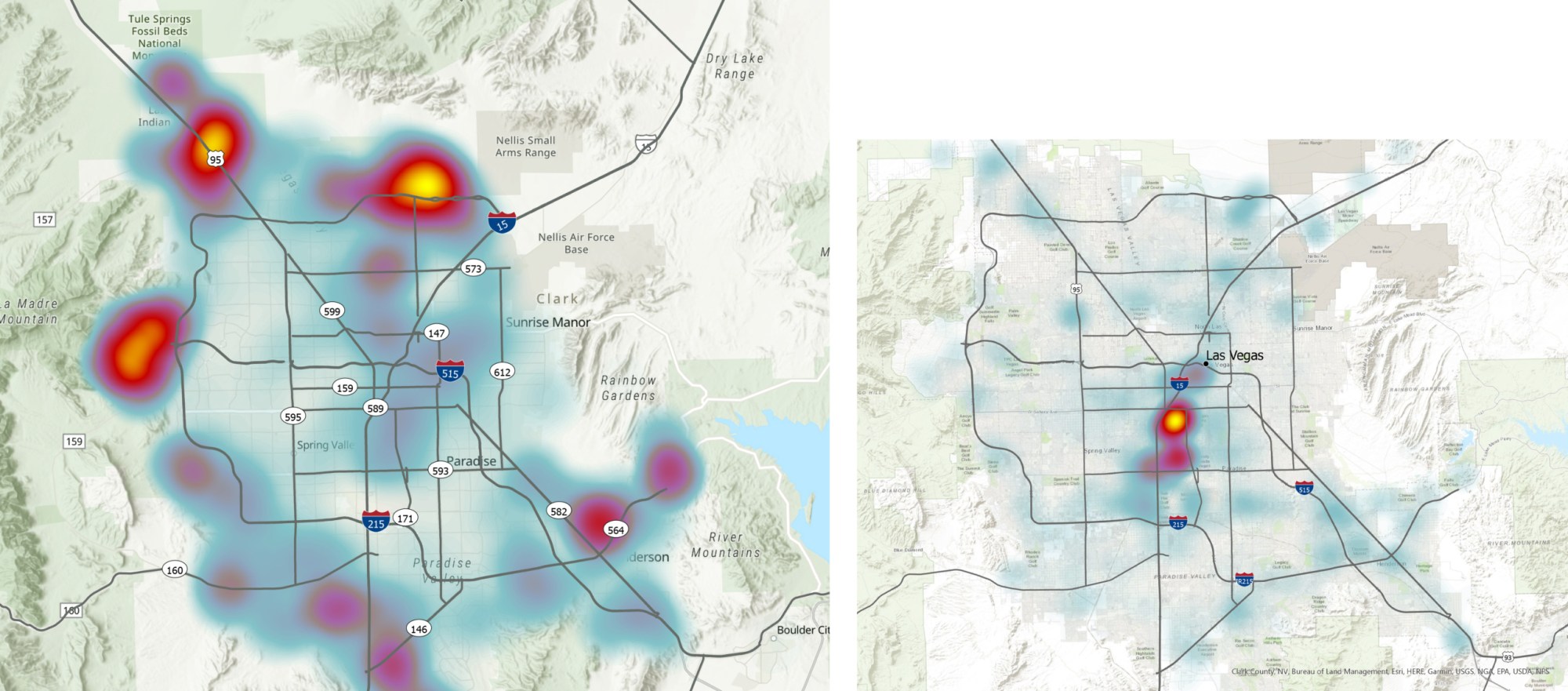
Left: Map showing population growth within the Las Vegas area by 2040. Map courtesy of the Nevada Department of Transportation. Right: Map showing employment growth by 2040. Map courtesy of the Nevada Department of Transportation.
This continued imbalance is neither preordained nor the result of external forces acting on southern Nevada, but rather a result of investment choices made principally by the Nevada Department of Transportation. For instance, in 2019, NDOT completed Project Neon, which widened a 3.7-mile stretch of I-15 through the heart of Las Vegas at a cost of $1 billion, making it the “largest and most expensive public works job ever undertaken” by the state.30 NDOT projects that traffic demand on this central corridor will roughly doubly over the next 20 years.31 In 2019, the year the project opened and the most recent year for which data are available and not affected by the pandemic, sections of I-15 expanded by Project Neon experienced daily traffic counts of up to 326,000 vehicles.32 Traffic counts along the project corridor have increased by roughly 28 percent since 2011. NDOT’s enormous investment in automobility has produced the expected increase in vehicular travel demand.
Project Neon will not be the last major widening undertaken by NDOT. In 2019, NDOT updated its large-scale traffic study for southern Nevada, which recommends a series of alternative major highway projects. These include lane expansion, reconfigured or expanded ramps and interchanges, and new connector and distributor roads that feed vehicles into and off of interstates and other arterial highways. According to the report, the expected population growth within the region will result in “an associated growth in freeway travel demand typically ranging from 25 percent to 70 percent or even higher.”33 The traffic study is intended to help the state to “plan and prepare for future capacity needs” and notes that “[t]he traffic forecasts are a valuable reference for use in future corridor studies, traffic impact studies, and other planning and design projects.”
List of Access 2040 projects
- S. 95/Kyle Canyon. Design and construct a new interchange.
- S. 95 North Package 2B. Durango to Kyle Canyon: Widen to six lanes, add auxiliary lanes, high-occupancy vehicle (HOV) drop ramps at Durango, and a new service interchange.
- Elkhorn Road HOV connection. Build U.S. 95 HOV ramp direct connects.
- Sheep Mountain Parkway. Construct a four-lane highway and interchanges.
- S. 95/CC 215 interchange. Complete a system-to-system interchange and local improvements.
- CC 215 northern Beltway. Widen to six lanes from Decatur to 5th Street.
- CC 215 northern Beltway. Widen to six lanes from Hualapai to Decatur.
- CC 215 western Beltway. Widen to six lanes from Craig to Hualapai.
- Peace Way bridge over CC 215.
- CC 215 southbound to Summerlin Parkway eastbound. Construct a direct connect ramp.
- Summerlin Parkway. Reconfigure Rampart westbound offramp to include an auxiliary lane from Rampart to Durango and a two-lane off-ramp at Summerlin Parkway triple lefts at Rampart off-ramp.
- Summerlin Parkway. Extend the HOV drop lane 1,500 feet west.
- Summerlin Parkway. Construct an auxiliary lane from the NB 215 off-ramp to Anasazi.
- Summerlin Parkway. Construct an auxiliary lane between Town Center and Rampart.
- Summerlin Parkway. Construct an eastbound auxiliary lane from Rampart to Buffalo and reconfigure the Durango eastbound on-ramp for an auxiliary lane.
- I-515. Construct a northbound auxiliary lane between Charleston Boulevard and Eastern Avenue and construct a southbound auxiliary lane between I-15 and Charleston Boulevard.
- I-215/I-515 system interchange. Move the I-515 southbound to I-215 westbound ramp from its current location to Lake Mead Parkway and create a two-lane on-ramp to I-215.
- I-215 southern Beltway at Airport Connector. Upgrade the interchange.
- I-15 at Sloan Road interchange.
- Via Nobila I-15 interchange, Via Inspirada from I-15/Sloan interchange to Via Inspirada/Bicentennial Parkway.
- I-15 at Starr Avenue interchange.
- I-15 express lanes. Convert lanes to HOV/GP lanes.
- I-15. Create Harmon and Haciena HOV ramp direct connects.
- Tropicana from Polaris to I-15. Widen and create a grade separation over Dean Martin and improvements to the Tropicana interchange.
- Project Neon. I-15/U.S. 95 interchange.
- I-15/CC 215 system-to-system interchange. Fourth leg of the interchange.
- I-15 North Part 2 Package A, C, D. Widen to six lanes, from Craig to Speedway.
- I-15 North Package 3. Widen to six lanes, from Speedway Boulevard to Apex.34
A future where population growth leads to steady increases in driving and pressure for highway capacity expansion is not a given. NDOT could choose a different investment mix that would place the region on a less auto-dominant trajectory—though there is little indication that the state will make the necessary changes. NDOT’s statewide transportation plan called the One Nevada Transportation Plan includes nonhighway projects and discusses providing residents with more and better options to driving. For instance, one of the plan’s major goals is to “optimize mobility,” which includes expanding “multimodal options for moving people, including walking, bicycling, and transit” and improving “connectivity between all modes of Nevada’s transportation system, including highways, rail, transit, and airports.”35 However, the overwhelming focus of the plan and the agency is on expanding highways and supporting automobility. For instance, the One Nevada Transportation Plan includes quantifiable performance goals. Under the section on optimizing mobility, the plan includes a goal on driving—specifically, the percentage of nonsingle-occupancy vehicle travel in urbanized areas.36 The 2016 baseline measure is 21.3 percent, and the goal is to increase this share to 21.6 percent, or an improvement in nonsingle-occupant trips—which are the least sustainable—of just three-tenths of 1 percent. This is not an aggressive attempt to alter travel behavior, to say the least.
Overall, the metropolitan context for the Boulder Highway project is not favorable. Yet, NDOT’s plans for the region should mostly not be held against the city of Henderson’s INFRA grant application. The reason is that Henderson has only modest input into the plans and investment decisions made by the state or RTCSNV. For instance, the board of commissioners that governs the work of RTCSNV includes eight members, only one of whom represents the city of Henderson. Thus, even the project priorities of the Las Vegas region only partially reflect the mobility, land use, and healthy community goals set forth by the city and embodied in its Boulder Highway project application. The U.S. DOT awarded the Boulder Highway project $39.8 million in the FY 2021 grant cycle.37
I-40 cap park in Nashville, Tennessee
The neighborhood of North Nashville is a historic Black community with a long history of strong economic activity, vibrant culture and arts, and educational leadership. The heart of the North Nashville neighborhood is Jefferson Street, which runs east-west and roughly parallels I-40. This area has three historically Black colleges and universities, including Tennessee State University, Fisk University, and Meharry Medical College.

Map of Nashville, Tennessee, cap park over I-40 and location of highway safety improvements. Map courtesy of Metro Nashville.
Beginning in the 1950s, the Tennessee Department of Transportation (TDOT) drafted plans for the construction of I-40, which runs east-west and stretches 2,554 miles from Wilmington, North Carolina, to Barstow, California.38 Initially, TDOT planned to locate the interstate parallel to Charlotte Avenue, which runs east-west roughly one mile to the south of where I-40 is located today.39 However, the initial alignment along Charlotte Avenue would have disrupted largely white-owned businesses and housing. As a result, TDOT altered the alignment, moving it to the north through the heart of North Nashville.
At roughly the same time, TDOT was planning and constructing what is today I-65, which runs north-south and sits along the eastern edge of the North Nashville community. Taken together, the construction of I-40 and I-65 in this area “demolished one hundred blocks of North Nashville, including sixteen blocks of stores along Jefferson St, and displaced 1,400 North Nashvillians.”40 In total, the highways displaced 128 Black-owned businesses, which “represented almost 80% of Nashville’s Black property ownership.”41
128
Number of Black-owned businesses displaced by the construction of I-40 and I-65 in North Nashville
In 1967, prior to the start of construction, a group of mostly Black community leaders and business owners formed a group called the I-40 Steering Committee to lobby TDOT to alter its plans. Ultimately, the steering committee filed a federal civil lawsuit against the state, seeking an injunction against construction based on Fifth Amendment due process and 14th Amendment equal protection claims.42 The steering committee lost its lawsuit and eventually appealed to the U.S. Supreme Court, which declined to hear its appeal, ending the litigation and allowing the build to move forward.43
The U.S. Court of Appeals for the Sixth Circuit clearly summarized the steering committee’s argument by stating that the I-40 route through North Nashville was selected “with the purpose of discriminating against the Negro or low socio-economic segments of Nashville’s population so as to damage and in part destroy the Negro business community of Nashville, injure predominantly Negro educational institutions, and impose other irreparable harm upon the North Nashville community.”44
Unfortunately, though not surprisingly, the court at the time found that the “plaintiffs have not shown that the selection of the proposed route amounts to a denial of due process of law or equal protection of the law”45 Today, the truth of the discriminatory route choices made by many state departments of transportation—including in Tennessee—is widely accepted. Metro Nashville Mayor John Cooper (D) strongly supports the cap park and recently stated that reconnecting the Jefferson Street community will go a long way to “correcting historic wrongs and bringing prosperity to our most vulnerable communities.”46 In December of 2020, Metro Nashville formally adopted Mayor Cooper’s $1.6 billion transportation plan, which includes the I-40 cap park and connector project.47
Primary assessment
The Nashville cap park and connector project is an attempt to join together two halves of the North Nashville neighborhood intentionally bifurcated more than 50 years ago by the construction of I-40. The project would involve the reconstruction of the Dr. DB Todd Jr. Boulevard Bridge over I-40 along with the addition of a 3.4-acre park. According to the application, “The bridge’s narrow, cracked sidewalks, unbuffered from narrow travel lanes with obstacles within the sidewalk, create a hostile pedestrian environment on this bridge and limit access between the north and south.”48 To date, Metro Nashville has not made any final determinations about how to program the park space but rather intends to engage in a process of deep community engagement to determine the final design.49
In addition, the project would involve improvements to I-40 intended to reduce frequent accidents at the I-40/I-65 interchange, often referred to as “Trucker’s Curve.” These elements include crash reduction improvements such as new signage and intelligent transportation system (ITS) features intended to better manage traffic and reduce accidents. In 2019, there were 24 truck-related crashes on Trucker’s Curve—roughly 20 percent of all crashes even though truck traffic represents 5 percent of vehicle trips through this portion of I-40.50
The I-40 cap park and connector project is an important step in a larger and more long-term process to reconstruct the North Nashville community and to foster inclusive prosperity. Already, Metro Nashville and other community partners are looking at ways to leverage the park, including through the construction of affordable housing nearby to ensure that the cap park amenity does not result in gentrification.51 Metro Nashville has committed $48 million—40 percent of the total estimated project cost of $120 million.52
Secondary assessment
The Nashville metropolitan area is growing rapidly, and TDOT remains committed to supporting low-density residential and commercial development through automobility, making the regional context not particularly favorable. TDOT has plans to expand both the interstate highway network, with particular focus on I-65, as well as other state and county roads around the metropolitan region with limited efforts to bend travel demand away from driving.
In 2018, TDOT completed its I-65 corridor study. The highway runs north-south for approximately 120 miles—including through Nashville—from the state’s northern border with Kentucky to its southern border with Alabama. The study reports that single-occupant vehicle (SOV) trips are the overwhelming commuting choice. In fact, unsustainable SOV commuting trips hover around 87 percent while transit trips account for between zero percent and 1.6 percent, depending on the origin-destination pair.53 TDOT has some high-occupancy vehicle (HOV) lanes to try and encourage carpooling but fails to enforce occupancy rules. According to a previous study, HOV occupancy violation rates in the Nashville region range from 65 percent to 96 percent of all vehicles using the lanes, depending on segment and time of day.54
TDOT’s solution has been to plan more highway expansion. The state recently announced the signing of its largest procurement contract ever for $160 million to fund the expansion of I-65 north of Nashville near the Kentucky border.55 This is just the first segment of I-65 that will be expanded in the coming years. In addition, TDOT has programmed numerous expansion projects on smaller state routes and other county facilities. For instance, along the southern metropolitan fringe, TDOT will expand East McEwen Drive from two to four lanes; expand state Route 397 from two to four lanes; expand state Route 96 from two to five lanes, and so on.56 Collectively, these and many other road-widening projects will support the creation of new low-density subdivisions that will generate maximal driving per capita.
On balance, Metro Nashville has a progressive vision of transportation and land use, including its strong support for the cap and connector project over I-40.
However, many of the projects advanced by TDOT should not be held against Metro Nashville. In December 2020, Metro Nashville adopted a $1.6 billion transportation plan that includes only two references to I-65 expansion projects but does not commit any local funds.57 Instead, these expansions are programmed with a mixture of federal and state highway dollars. A review of the regional long-range transportation plan put together by the Greater Nashville Regional Council, which serves as the metropolitan planning organization, shows a more mixed program. In general, TDOT is the project sponsor for many of the highway and arterial roadway-widening projects—though Metro Nashville is a co-sponsor or lead on a handful. On balance, Metro Nashville has a progressive vision of transportation and land use, including its strong support for the cap and connector project over I-40. The U.S. Department of Transportation did not award the I-40 cap project any funding in the FY 2021 grant cycle.
I-30 in Dallas
Like in many cities, downtown Dallas is tightly circumscribed by major highways, including Interstate 30, which runs along the southern edge of the central business district. The section of I-30 that runs past downtown is a below-grade trench known as the Canyon, which opened to traffic in 1965.58 The Texas Department of Transportation (TxDOT) has submitted an application to the INFRA grant program to address two broad problems with this stretch of interstate.
First, the area north of the I-30 Canyon has experienced decades of sustained economic growth and development while the area to the south, known as the Cedars, “has, until only recently, remained underdeveloped, isolated, and somewhat excluded from the city’s economic growth.”59 Recent data paint a stark picture. For instance, in 2019, the median household income in the Cedars was less than $29,000 per year compared with $68,000 in central Dallas.60 In addition, as TxDOT correctly points out, “[S]egregation along interstate lines drawn decades ago persists today.”61
Second, the I-30 Canyon corridor experiences frequent and severe congestion due, in part, to the suboptimal design and configuration of the existing interstate mainlines and parallel frontage roads. According to TxDOT, “In 2020, the I-30 Canyon was part of the 15th most congested roadway segment in Texas for trucks, out of a total of 1,860 segments.”62
TxDOT’s I-30 Canyon project includes five elements: 1) a partial restoration of the local street grid that was severed in the 1960s by the construction of the I-30 segment; 2) inclusion of complete street design elements intended to support more biking and walking; 3) a smaller I-30 right-of-way footprint that will free up 14 acres of land for redevelopment principally within the Cedars neighborhood; 4) improved freight, intercity passenger, and light-rail crossings over I-30; and 5) a substantial reconstruction of I-30 intended to increase overall capacity and improve the flow of traffic.
Primary assessment
The I-30 Canyon project includes several positive elements that will further nonmotorized trips and transit use. For instance, element four will expand freight and passenger rail service by not only rebuilding the rail crossing over I-30 but also adding an additional track that could support additional service frequency. The inclusion of complete street design elements will also help to expand nonauto mobility options. Yet, these elements, which receive heavy attention in the application narrative along with a focus on community engagement in the planning process, are undermined by element five. In fact, 60 percent to 70 percent of the $496 million construction budget is dedicated to making improvements to the capacity and flow of highway traffic on I-30.63 The total project cost—including utility relocation, right-of-way acquisition, and engineering—is $564.7 million.64 According to TxDOT:
Improvements within the I-30 right-of-way will untangle the existing network of highway, frontage road, and collector-distributor lanes to deliver a safer and more efficient roadway. The project includes removing the collector-distributor system, adding mainlane capacity and discontinuous frontage roads, reconfiguring the Cesar Chavez interchange to a simple diamond interchange with connections to I-30, and other changes that simplify ramps and access to downtown.65
Perhaps not surprisingly, TxDOT’s cost-benefit analysis shows that benefits related to vehicle movements—including avoided crashes, lowered vehicle operations costs, travel time savings, and freight reliability—outweigh benefits associated with nonmotorized access, quality of life, and new developable land by nearly a 2 to 1 ratio.66 Stated differently, a project designed principally to improve vehicular capacity and flow produces robust vehicular benefits.
It is difficult to square the idea of environmental justice with a project principally designed to improve throughput on I-30.
Within its application, TxDOT argues that “[t]he I-30 Canyon project takes steps to repair the climate change and Environmental Justice (EJ) legacy of the Interstate Highway System.” This claim is a stretch. As evidence, TxDOT notes that the new crossings and complete street design elements—which are important—along with the fact that a small share of project funds will “convert traffic lights and streetlights to LEDs.” It is difficult to square the idea of environmental justice with a project principally designed to improve throughput on I-30—especially when the overwhelming majority of the heavy-duty trucks and light-duty vehicles that will use the redesigned corridor will be powered by internal combustion engines, emitting a steady stream of pollution concentrated within the airshed of the Cedars, for decades to come.
![]()
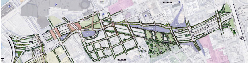
Rendering of possible cap parks and other local mobility improvements. Rendering courtesy of the Texas Department of Transportation.
TxDOT goes to some length to demonstrate within its application that the I-30 project is the result of extensive community engagement. “The reimagining of the I-30 Canyon was founded on community input. More than 80 listening sessions and public meetings were conducted through the CityMap process.”67 Yet, the overall project focus on highway improvements does not align well with community desires for the area. According to TxDOT, the community outreach process determined that residents “placed the highest value on quality of life and neighborhood character, community and urban streets, and economic development.”68 The I-30 capacity and flow improvements are about moving people and freight through Cedars, and this is reflected as much by those project elements included in the proposal as those left out.
For instance, the main text of the application highlights that “the further compression of I-30 provides an opportunity for up to four deck parks above the interstate connecting downtown to South Dallas, subject to local funding.” A footnote clarifies that “[t]he deck parks are not included in the cost of I-30 Canyon project, but could be made feasible for local and/or private funding.”69
The new highway crossings, complete street design features, and creation of 14 acres of new developable land principally within the Cedars combine to make the I-30 Canyon project more equitable and sustainable than a straight highway expansion project. However, the heavy emphasis on expanded highway capacity and improved flow along I-30 will likely produce a net increase in driving and auto dependence. Overall, the primary assessment reveals a moderately progressive project. Depending on the quality of the other INFRA applications, this could be enough to bump the project from a grant award.
Secondary assessment
An evaluation of the Dallas-Fort Worth area transportation context is sufficient for the secondary assessment. The North Central Texas Council of Governments serves as the metropolitan planning organization for the region. The portion of the transportation improvement program that includes brief project profiles stretches to more than 360 pages and includes an exhaustive list of transportation projects under development along with total cost information. A partial review of the council’s current TIP shows more than $6.5 billion in arterial roadway and highway-widening projects.70
Taken together, these projects, for which TxDOT would typically serve as the implementing agency, represent a coherent strategy to deepen automobility, expand unsustainable low-density land use, and raise climate emissions. For instance, project 1605-02-024, which will cost $95 million, will widen a “2 lane rural [roadway] to 6 lane urban divided” highway.71 This type of project serves as the foundation for new subdivisions and the resulting auto trips that low-density housing and commercial development will produce. Yet, new growth on the periphery also produces increased demand on existing major limited-access highways, including interstates since a large share of the traffic generated at the periphery ends up making trips to the central business district and other major activity centers. The council and TxDOT have this covered as well with projects such as 0008-13-12, which will cost more than $1 billion and will expand Interstate 820 along the eastern edge of Fort Worth.72
TxDOT argues in its grant application that the I-30 Canyon project is a “key to unlocking new possibilities for greener, multimodal transportation opportunities in Dallas.”73 Another key to advancing greener, multimodal transportation is to stop repeating the same formula of endless highway expansion in support of low-density development that fosters maximal driving and auto dependence. In short, the regional context shows that the progressive elements of the I-30 Canyon project are largely an outlier within a program of projects that will extend the auto-dominant status quo for decades to come. The U.S. Department of Transportation did not award the I-30 Canyon project any funding in the FY 2021 award cycle.
Conclusion
The lack of meaningful policy reform to surface transportation formula programs authorized by the IIJA increases the importance of maximizing the progressive impact of competitive grant awards. By leveraging the discretion afforded to the secretary of transportation to require progressive project elements, the Biden administration has an unprecedented opportunity to push states and metropolitan regions to implement transportation projects that reduce driving and increase mobility choice as well as facilitate more compact and sustainable land use. The primary and secondary assessment framework put forth in this report offers DOT a method for rewarding the most progressive project while also taking into consideration the broader transportation context. By clearly showing applicants that the broader transportation context will factor into grant awards, DOT can pressure states and regions to use their formula dollars in more progressive and sustainable ways.