Building infrastructure is an inherently political act of creation. Every investment choice lays the foundation for a future that could have been otherwise. Yet, infrastructure needs are typically presented as dispassionate, objective facts. In truth, infrastructure is the physical manifestation of both political power and social values. The design, location, scale, and scope of what governments build reflect social, economic, and political power in society. All too often, the benefits of access and opportunity flow to dominant racial and industry groups, while the burdens of disinvestment, pollution, and geographic isolation fall on low-income communities and communities of color.
Only by working through often messy and contentious deliberative planning processes with deep public engagement can a society determine what it needs to build. The technical expertise of engineers and scientists cannot circumvent the political nature of allocating scarce investment resources. Professional experts can and should inform the debate by providing insights into what is feasible and about the trade-offs of different investment alternatives. Stated differently, technical experts can answer the empirical question of what can be built—but never the normative question of what should be built.
This simple fact has important implications for infrastructure policy. First, there is no such thing as an objective needs estimate that is decoupled from politics. Instead, need is generated through collective debate about the type of future that infrastructure dollars should help to build. Second, the debate about infrastructure investments should begin with values and goals—not projects. Without a clearly defined purpose, infrastructure plans become shortsighted exercises in horse trading one project for another instead of a coherent blueprint for advancing a community’s vision.
Third, the political nature of infrastructure applies to every category of investment, including new construction, technology adoption, maintenance and reconstruction, and operations. Importantly, because investment in all forms is an act of creation, infrastructure plans should not be bound by the past. There is no mandate or intrinsic rationale for reinforcing the politics and project-selection decisions of prior generations.
This issue brief provides examples that demonstrate the political nature of each investment category, beginning with alternative proposals for the construction of a new transbay crossing in the San Francisco Bay Area. The bridge and tunnel alternatives show how building a new crossing will shape the transportation choices and development pattern of the region for decades to come.
Next, the brief looks at a theoretical artificial intelligence-based transit fare payment system to understand how values inform technology adoption, including the trade-offs between privacy and efficiency. The brief then considers the politics surrounding repair and reconstruction, using the example of Interstate 81 (I-81) in Syracuse, New York, to show what communities can achieve when they are not bound by the past. The brief concludes with a review of two operational changes in the Los Angeles transportation system that illustrate the politics of asset use and prioritization.
Construction
The San Francisco Bay Area has experienced decades of strong population and economic growth, which have placed enormous strain on the existing transportation system—especially the Bay Area Rapid Transit (BART) heavy-rail line and the San Francisco-Oakland Bay Bridge. In response, the Association of Bay Area Governments (ABAG) and the Metropolitan Transportation Commission (MTC), which are responsible for transportation and growth planning for the Bay Area, released a report that evaluates seven different new transbay crossing alternatives.1
These crossing alternatives vary in terms of both their geographic location and transportation mode. They include two alternatives for automobiles only, two for BART only, one for BART and automobiles, one for BART and commuter rail, and one for commuter rail only. The cheapest alternative is a new auto bridge connecting San Mateo and Hayward, which has an estimated total cost of $15 billion. The most expensive is a pair of new rail tunnels capable of serving BART and an expanded commuter rail, which has an estimated total cost of $98 billion.2
Even in a comparatively wealthy region such as the San Francisco Bay Area, government financial resources are limited. According to MTC planning documents, the average cost of roadway and transit projects scheduled for completion within the next four years in the Bay Area is $77 million.3 The $15 billion bridge, therefore, is equivalent to the cost of 195 projects, and the $98 billion rail option is equivalent to the cost of 1,273 projects.4 Ultimately, the enormous cost differential among the seven alternatives means that the final choice will reduce—to a greater or lesser degree—the region’s ability to complete other transportation priorities.
Beyond cost, each alternative would have profound and unequal long-term effects on regional development, including housing and job growth; land use; and transportation productivity and mode share, which is the percentage of trips taken by private vehicles, public transit, biking, and walking, among other outcomes. The MTC has adopted numerous performance goals to guide its project investment decisions, including increasing “non-auto mode share,” focusing development “within [the] urban footprint,” and reducing “per-capita CO2 emissions.”5 Importantly, these goals are the result of a political debate about what the region should value and prioritize.
According to the MTC, 72 percent of area residents commute by car, 12 percent commute by transit, and 4 percent commute by walking. The time burden for each of these modes varies significantly. The average transit commuter spends 51 minutes traveling to work—70 percent more time than the average auto commuter, who spends only 30 minutes driving to work. Building a new auto bridge would reinforce the travel time advantage of driving over riding transit. Not surprisingly, the MTC’s analysis shows that the shorter travel time for driving would lead to an increase in auto mode share and a decrease in transit mode share over time.
The overall transportation productivity of the seven options vary substantially. For example, the two auto-only bridge options would support at most 6,000 additional vehicle crossings per hour during the morning and evening peak periods. By comparison, the BART-only tunnel options would each support 25,000 additional trips per hour during the peak periods. Finally, the BART and commuter rail option would support 53,000 additional trips per hour.6
The choice of transbay crossing will also affect land use. According to the MTC, growth in the Bay Area consumes more than 2,000 acres of greenfield land each year.7 Building a new rail crossing for BART would result in either 15 or 16 new transit stops, depending on the final design choice. These stops would anchor new infill urban development, helping reduce low-density, auto-dependent growth along the region’s periphery. A new auto-only bridge would support the inverse, undermining the closely related goals of focusing growth within the existing urban footprint and reducing per capita carbon dioxide emissions.
The San Francisco Bay Area faces a political choice filled with difficult trade-offs about how to invest its limited infrastructure funds. The ABAG/MTC technical analysis can inform this debate, but it cannot answer the normative question of what the region should build. Only when stakeholders and community residents have come to a decision through informed debate can a need be said to arise. This same reasoning applies across infrastructure sectors, making any needs estimate that is a simple extrapolation of the status quo meaningless.
Technology adoption
The political nature of infrastructure extends beyond the built environment to include advances in technology that affect system operations. For example, transit authorities have tried for years to improve fare payment systems to speed passenger boarding and reduce dwell times at bus stops. The idea of using technology to improve efficiency does not seem objectionable or political; however, efficiency is not a neutral value, and prioritizing efficiency comes with trade-offs.
Imagine that a technology company approaches a local public transit agency with a new fare payment system that uses facial recognition powered by artificial intelligence. The firm pitches the agency on the potential for both huge efficiency improvements as well as the ability to track rider behavior, including fluctuations in demand due to price or schedule changes, by income, geography, and race and ethnicity. No longer would buses idle as passengers fed crumpled-up dollars into the farebox or repeatedly swiped a farecard trying to trigger the radio-frequency identification sensor. Instead, a camera system would instantly identify boarding passengers and charge their accounts. Additionally, the facial recognition system would be able to track where passengers alighted, providing a level of ridership data precision heretofore impossible. The granular data would allow the transit authority to deploy its bus assets in the most efficient manner possible, helping boost overall ridership without the need to acquire additional buses.
Should a facial recognition-based payment system powered by artificial intelligence be considered a need? Again, the answer to this question is political—though ideally informed by technical analysis. For example, a cost-benefit analysis could consider how much the new system would cost and compare that to the net present value of time that riders save due to more efficient boarding over the expected life of the system. Another technical analysis could estimate the operational and capital trade-offs that would result from adopting the new system. Yet, there is no economic or scientific analysis that can answer the fundamentally political question: Should a transit operator use facial recognition technology?
A key element of deliberative democracy is that citizens determine their hierarchy of values. A facial recognition system may dramatically speed the boarding process and reduce run times compared with the status quo, but this fact is irrelevant if residents decide to value privacy over efficiency. Infrastructure need, therefore, is a consequence of public deliberation—not a fact that exists outside the political process.
Maintenance and reconstruction
The political nature of infrastructure spending is not limited to building new facilities or adopting cutting-edge technologies. Even maintenance and reconstruction are inherently political. Resource limitations mean that repairing one facility often comes at the expense of repairing or constructing something else. The flow of infrastructure funds creates winners and losers, and investment decisions often favor dominant groups or industries.
Additionally, repair and reconstruction projects are political because infrastructure design choices have important social, economic, and environmental ramifications. The example of I-81 in Syracuse helps to make this point. In the late 1950s, New York state decided to locate what would become I-81 through the heart of Syracuse, following roughly along the alignment of Almond Street.8 Engineers chose to elevate the highway for roughly 1.4 miles through the center of the city to minimize disruption to vehicular traffic on local streets.
The elevated segment—known as a viaduct—has come to the end of its useful life, and the New York State Department of Transportation (NYSDOT) faced a difficult decision about how to proceed. According to environmental review documents, reconstruction, including some design modifications, would take six years to complete; require the acquisition of 24 buildings; and cost at least $2.2 billion.9 Replacing the viaduct with a tunnel would take 11 years to complete; require the acquisition of 17 buildings; and cost at least $4.9 billion. Finally, replacing the viaduct with a signalized, at-grade boulevard would take five years to complete; require the acquisition of four buildings; and cost $1.9 billion.10 Following a lengthy period of study and community engagement, the state selected the boulevard concept.11
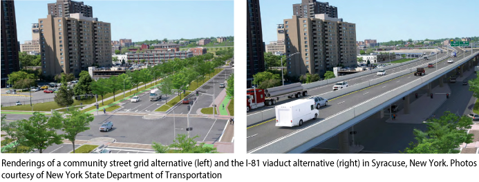 Choosing to tear down the existing viaduct and replace it with an at-grade boulevard is significant for two reasons. First, the lower estimated total project cost will allow the NYSDOT to complete additional projects around the state. Second, and equally as important, an at-grade boulevard that integrates into the local street grid produces a much different urban form than a hulking viaduct that bisects the city center. The scale, location, and design of infrastructure facilities affect how people move, interact, and access community resources, including employment, health care, and education, to name only a few.
For example, a boulevard can easily accommodate transit service, cyclists, and pedestrians, while an elevated, limited-access highway cannot. According to the environmental review documents, the boulevard project will reconstruct Almond Street and include “widened sidewalks, a landscaped median … bicycle lanes, raised cycle tracks, and shared use (bicycle and pedestrian) paths in various segments along Almond Street, as well as some adjacent streets.”12 The inclusion of transit service and nonmotorized facilities provides high-quality, affordable transportation alternatives that deliver mobility and health benefits to residents of all ages and income levels.
A limited-access highway places high-speed automobility at the top of the hierarchy of values and project objectives. To advance the supremacy of automobility in the early days of the interstate highway era, the NYSDOT constructed a viaduct that split the city into halves. In short, the highway came at the expense of a cohesive urban form. If the NYSDOT had chosen to reconstruct the viaduct, it would have reaffirmed this value hierarchy and the distribution of benefits and burdens that flow from prioritizing automobility. By selecting the boulevard design, the NYSDOT will ensure that Syracuse has a more cohesive and accessible urban form for decades to come.
Repair and reconstruction are never just repair and reconstruction; they are every bit as political as every other project choice. With respect to need, Syracuse residents can now say clearly that they need a boulevard with an estimated total cost of $1.9 billion. The political process of debating the region’s future was triggered by the deteriorating condition of the existing viaduct. Only after working through the challenging process of assessing different alternatives and weighing their trade-offs could the region determine its need.
A standard approach to estimating infrastructure need would simply estimate the cost of replacing the deteriorated asset. This approach is invalid because it attempts to circumvent an inherently political process under the veneer of objectivity. The I-81 viaduct in Syracuse has come to the end of its useful life. Only a political debate informed by technical expertise and deep community engagement can determine what should be done about this fact.
Operations
Finally, the operation of existing facilities is also political. For example, in 2016, the Los Angeles County Metropolitan Transportation Authority (LA Metro) completed the Expo Line, a light-rail line that runs along Exposition Boulevard. The design of the facility includes a mixture of at-grade and grade-separated right of way.13 This means that trains run on elevated tracks over some intersections and at ground level through others. This design choice helped to significantly reduce the total cost of the project, but it created an inherent conflict between trains and cars. Currently, Expo Line trains make frequent stops to wait until a gate lowers to halt traffic and allow the trains to pass.
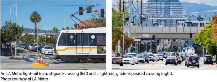 This operational procedure prioritizes the movement of vehicles and the travel time of drivers over the movement of trains and the travel time of passengers. Privileging the speed of private vehicles—which typically carry one person—over a train carrying dozens or even hundreds of people is a political choice. The operational procedure could be reversed to prioritize train movements over cars. In March, the Los Angeles City Council approved a measure directing the Los Angeles Department of Transportation to work with LA Metro to prioritize train movement along the entire line so that trains no longer need to stop at intersections to wait for cars.14 The change will reduce run times for Expo Line trains as well as improve overall time performance, helping to attract more riders and help the region achieve its goal of reducing the share of single-occupant vehicle trips.15
Similarly, the city of Los Angeles and LA Metro have begun implementing a plan to prioritize bus service, including the conversion of mixed-use roadway lanes into bus-only lanes.16 Like the Expo Line signal changes, this plan is about rebalancing the priority for the use of existing assets. Los Angeles County has more than 7,000 lane miles of roadways.17 Establishing bus-only lanes is not about expanding the roadway network but rather about choosing to prioritize transit users over drivers. In a dense urban environment, there are few acts more political than choosing how to allocate limited public right of way.
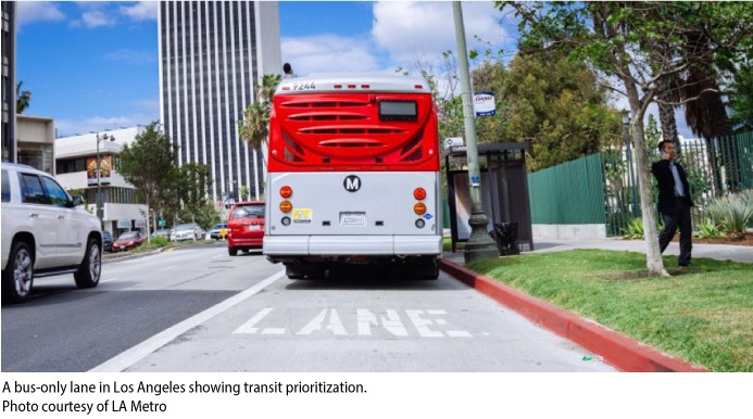 According to LA Metro’s long-range plan, the authority will convert “strategic Metro Rapid corridors to bus rapid transit (BRT) corridors as part of an effort to establish a network grid of high-frequency, high-capacity, fast bus service across LA County.”18 As part of the implementation of this plan, LA Metro will use “signal priority, queue jumps, and enforcement of exclusive lanes, to achieve a minimum average speed of 18 mph.”19
Light-rail signal prioritization and bus-only lanes are part of a larger project to fundamentally change how residents of Southern California move. Increasing the quality, productivity, and ridership of transit is part of a regional commitment to improving air quality and combating climate change, which is itself the largest and most challenging collective political action problem humanity has ever faced. Operational changes to transit systems and roadways cannot be understood outside of this political context.
Conclusion
Infrastructure need does not simply exist; it is a downstream consequence of political choices informed by values and technical analysis. Instead of asking how much infrastructure we need, the policy conversation should begin with the question, “What are we trying to achieve?” The main benefit of starting with the latter question is that it shifts the conversation away from assets and toward outcomes. Only when people have debated and ultimately determined what their economic, social, and environmental goals are for future investments will the development of an infrastructure plan become a valid process.
In the messy world of deliberative democracy, the political process of debating infrastructure investment goals and implementation plans will inevitably devolve into an imperfect version of an idealized process. However, no matter how clunky it may be, focusing the deliberative process on outcomes is essential to infrastructure planning because the stakes are so high. Infrastructure assets last for decades. The decisions that elected officials, planners, and the public make collectively will shape economic production, social mobility, and environmental health, among other outcomes, for many decades.
Kevin DeGood is the director of Infrastructure Policy at the Center for American Progress.