Infrastructure is the foundation of America’s society and economy. Yet not all investments are worthwhile. In fact, unnecessary projects create a long-term, unproductive cost burden—a form of infrastructure overhang. The “White Elephant Watch” series profiles projects that demonstrate the failures of the current U.S. policy approach to transportation infrastructure.
Under current federal transportation policy, states are not held accountable for their investment decisions. Instead, the federal government provides states with dedicated highway money, which reflects the political power of certain elected officials and regions as opposed to local needs or potential returns on investment. Under this system, states are not required to demonstrate the social, environmental, or economic value of their projects. Beyond certain procedural and design requirements, states have total discretion, which often results in projects that fail to provide clear benefits or to advance national transportation policy objectives.
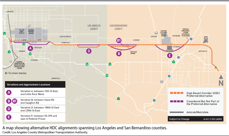
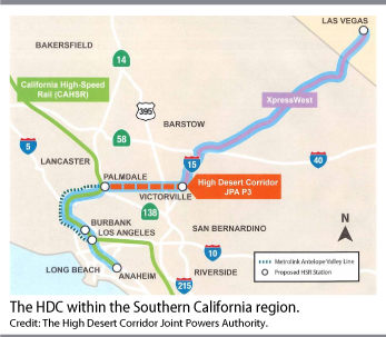
The steady flow of federal funds means that even highly questionable projects can advance. For instance, the California Department of Transportation (Caltrans) has proposed to build a new highway known as the High Desert Corridor (HDC). The new highway would extend approximately 63 miles from state Route 14 in Palmdale, within Los Angeles County, to state Route 18 in the town of Apple Valley, within San Bernardino County.1 In addition, Caltrans is considering the possibility of running rail tracks down the median of the highway facility. The tracks would link future California high-speed rail service passing through Palmdale in Los Angeles County with future passenger rail service to Las Vegas offered by Virgin Trains USA out of Victorville in San Bernardino County.
The proposed HDC has three major flaws. First, it would extend along the northern, exurban fringe of the Southern California metropolitan region, facilitating low-density, auto-dependent development for decades to come. This development pattern would increase single-occupant vehicle trips and mobile-source emissions, running counter to the state’s climate and sustainable communities goals. Second, the facility would fail to increase transportation choice or improve access to major employment centers in the San Fernando Valley, the Los Angeles Basin, or the San Bernardino Valley. Third, the east-west highway would result in substantial environmental harm.
The project has an initial estimated cost of $8 billion.2
California’s climate and sustainable communities goals
For decades, California has been at the vanguard of the environmental movement. In 1947, Los Angeles County established the nation’s first authority to control air pollution with the creation of its County Air Pollution Control District.3 In 1967, the state established the California Air Resources Board (CARB), which is responsible for improving air quality as well as achieving statewide greenhouse gas (GHG) emission reduction targets.4
A central element of CARB’s work is the regulation of motor vehicle emissions.5 The state invested CARB with broad regulatory power over vehicles because it determined that “the emission of air pollutants from motor vehicles is the primary cause of air pollution in many parts of the state.” Furthermore, the state determined that controlling and eventually eliminating vehicle emissions is necessary “for the protection and preservation of the public health and well-being.”6
More recently, the state has taken aggressive steps to limit GHG emissions to combat global warming. In 2006, the state enacted A.B. 32, known as the Global Warming Solutions Act. The legislation provided CARB with the authority to regulate sources of GHG emissions and required statewide emissions to reach 1990 levels by 2020.7 A decade later, the state strengthened its climate goals by enacting S.B. 32, which requires CARB to adopt rules and regulations that will ensure that statewide GHG emissions fall 40 percent below 1990 levels by the end of 2030.8
Importantly, the state understood that only regulating the carbon content of fuels and tailpipe emissions would be insufficient to achieve its air quality and global warming prevention goals. In 2008, the state enacted S.B. 375, the Sustainable Communities and Climate Protection Act.9 This legislation reformed transportation planning to require regional agencies to develop project lists and transportation plans that would achieve regional GHG emissions targets set by CARB.
S.B. 375 recognized that land use and the built environment deeply affect the movement of people and freight and therefore emissions of both criteria pollutants under the Clean Air Act and GHGs.10 Stated differently, more compact communities with multimodal transportation systems are less polluting and carbon intensive because they allow people to travel shorter distances without always having to drive. S.B. 375 found that improving land use efficiency is so vital to achieving GHG targets that “without improved land use and transportation policy, California will not be able to achieve the goals of AB 32.”11 In 2018, CARB released a progress report on the implementation of S.B. 375, finding that “California cannot meet its climate goals without curbing growth in single-occupancy vehicle activity.”12
To comply with S.B. 375, regional agencies must incorporate a new element into their long-range transportation plans known as the sustainable communities strategy. The Southern California Association of Governments (SCAG) serves as the regional transportation planning agency for Los Angeles, Riverside, San Bernardino, Ventura, Orange, and Imperial counties. Under federal law, SCAG is also designated as the metropolitan planning organization (MPO). CARB has mandated that SCAG develop a long-range transportation plan that will reduce per capita GHG emissions from cars and light trucks by 13 percent below 2005 levels by 2035.13
SCAG’s long-range transportation plan and sustainable communities strategy establishes multiple goals, including making investments in projects that will encourage “land use and growth patterns that facilitate transit and active transportation.” Additionally, SCAG wants to “protect the environment and health of our residents by improving air quality and encouraging active transportation (e.g., bicycling and walking).”
The plan also contains numerous performance measures focused on improving location efficiency and reducing mobile source emissions. For example, the plan seeks to increase the share of growth within high-quality transit areas and the share of total trips taken by transit. Additionally, the plan seeks to reduce land consumption; per capita vehicle miles traveled; Clean Air Act criteria pollutants and GHGs; among others. SCAG’s sustainable communities strategy declares that:
Planning that does not strive for this close integration [of transportation and land use] can result in sprawling suburbs connected haphazardly to poorly managed highways and isolated communities that lack easy access to public transportation connecting people from home to work, school and other destinations. Precious resources are squandered: time, energy, money, productivity, clean air and good health, among others.14
Overall, SCAG’s long-range plan clearly articulates the negative effects of low-density, auto-dependent development that increases pollution, cannibalizes resources, and creates geographic dislocation from economic opportunity and critical services, among other harms. Yet SCAG is simultaneously working with Caltrans and other local governments to advance the High Desert Corridor, which would undermine the state’s clean air, climate, and land-use goals.
A review of the approved transportation projects for the Southern California region reveals $46 million to advance HDC project approvals and environmental documents. In addition, the successful 2016 Measure M ballot initiative includes approximately $2 billion for the HDC with funds slated for 2063–2067.15
The HDC would be a step backwards
California has established a progressive regulatory framework intended to rationalize and coordinate planning at all levels of government to achieve clean air, global warming, and sustainable growth policy goals. Unfortunately, the HDC is the antithesis of all these goals. The HDC would lay the foundation for extending a development pattern that SCAG and the state have identified as deeply problematic.
Under California Environmental Quality Act (CEQA) rules, SCAG was required to analyze its long-range plan for compliance with air quality and climate change regulations. According to SCAG’s technical analysis, the long-range plan is compliant. Specifically, the review found that implementing the plan would result in a 13 percent reduction in per capita GHG emissions below 2005 levels by 2035. Moreover, the plan would “generally improve air quality…[and] reduced diesel particulates.”16
There is no reason to question the validity of SCAG’s finding. However, this result is not absolution for the HDC. SCAG’s goals—including building more high-quality transit neighborhoods, reducing per capita vehicle miles traveled, and zoning for more multi-family housing near job centers in one part of Southern California—should not be viewed as creating a bank of emissions reductions that can be expended on poorly conceived projects in another part of the region.
Pursuing the HDC would mean that SCAG and Caltrans have one set of transportation and development rules for certain areas and a different set for others. Yet, the value of efficient land use, transportation choice, and walkable communities with abundant housing is equally applicable in the High Desert as it is in downtown Los Angeles. One way to think about SCAG’s long-range plan is that the authority is trying to retrofit the suburban-style development of Southern California to become something more uniformly urban in character. Building the HDC would place the High Desert region on an exurban growth trajectory that would need to be retrofitted decades from now. A far more rational approach would be to build a sustainable transportation system from the start, since retrofitting the built environment is far more costly and challenging.
The issue of air quality demonstrates the illogic of the HDC. According to the environmental review, most air pollution is carried into the High Desert area by a daily onshore breeze originating over the Pacific Ocean. This breeze collects criteria pollutants and pollutant precursors as it passes over a heavily developed portion of the Los Angeles Basin.17 According to Caltrans, “this meteorological pattern will, therefore, make it difficult for the area to achieve clean air until sources in the developed portions of the basin are better controlled and less pollution is carried downwind across communities within the Antelope Valley.”18 The sprawling, auto-dependent Los Angeles Basin is a potent source of air pollution in need of deep remediation, but SCAG and Caltrans want to duplicate the development pattern in the High Desert area.
Purpose and need for the High Desert Corridor
Like many unbuilt highways, the idea for the HDC has been around for a long time. As far back as the 1970s, planners discussed the possibility of an HDC that would serve as a “metropolitan bypass” for drivers heading east from Interstate 5 to cities in San Bernardino County.19 The reality of transportation planning is that highways never die. Instead, their underlying justifications shift over time to meet the concerns of the moment. A 1970s metropolitan bypass can be repackaged with the aid of a few solar panels and charging stations as a green energy corridor in the 21st century.
The environmental impact statement (EIS) for the HDC states that the purpose of the facility is to “increase capacity of west-east transportation facilities to accommodate existing and future transportation demand.”20 For Caltrans, population growth is the central justification for the new highway; in fact, the traffic study lists “addressing current and future regional growth” as the primary goal.21 This is a perfectly suitable goal for Caltrans to pursue. Unfortunately, Caltrans’ preferred solution is both deeply unsustainable and runs counter to the SCAG’s development goals for a large portion of the High Desert region.
According to Caltrans’ traffic study, the majority of the 61-mile corridor linking Palmdale in Los Angeles County with Apple Valley in San Bernardino County is “rural in character and its zoning designation is predominantly low density residential.”22 Moreover, “preservation of the rural character of the region is the common vision which unites the communities of the High Desert area.” To be clear, building a high-capacity highway with approximately 20 interchanges will subvert this community preference and induce additional development. Yet, the resulting growth will fall within a band that is dense enough to displace the rural character of the area but not dense enough to meet SCAG’s land use goals.
Overall, the traffic study found that building the HDC would reduce vehicle delay because the new facility would pull some trips off the existing arterial roadway network.23 This result deserves some skepticism, as the study did not contain any discussion of induced or latent demand.24 Induced demand is a term that describes the additional trips that residents would like to take if the roadway system were less congested. Once space opens up, residents take more trips until the point at which the system returns to a congested state. If the traffic study had accounted for induced demand, vehicle delay improvements would have been lower.
Importantly, both the EIS and the traffic study looked at five different highway alignment alternatives but no local transit option.25 This omission is problematic because adding pavement is not the only way to increase capacity. State Route 138, which becomes state Route 18, already provides east-west mobility for the communities that the HDC would serve. A purchase of service agreement or the establishment of a joint powers authority would allow the Antelope Valley Transit Authority and the Victor Valley Transit Authority to provide high-frequency express bus service along state Route 138/18 to meet growing east-west travel demand to the extent that it materializes; a review of current origins and destinations for vehicle trips found little east-west demand. Not surprisingly, most trips occur on state Route 14 by residents of Palmdale and Lancaster. And in San Bernardino County, most trips are on Interstate 15 and U.S. Route 395.
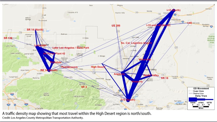
As part of the overall project review, Caltrans prepared a growth impact analysis. The analysis determined that, “the [HDC] project would not likely cause extensive development at proposed interchanges located in the rural central portion of the alignment corridor.”26 However, the above traffic density map undermines this conclusion.27 Land has value when it can be accessed. It’s not a mystery why growth in recent years has clustered around the access and mobility provided by state Route 14, U.S. Route 395, and Interestate 15. Building the HDC would necessarily open up land to residential and commercial development that is currently uneconomical.
Additionally, the analysis determined that the new highway “would tend to shift some future development toward the new interchanges in Palmdale and Victorville/Adelanto.”28 In other words, the analysis is saying that a portion of construction activity that would occur along existing north-south highways in the absence of the HDC will instead cluster around the urban segments of the area. This finding raises an even more important challenge to the HDC because of the mismatch between Caltrans’ stated purpose and need for the HDC and the actual benefits it would produce.
According to Caltrans, the purpose and need for the HDC is to “increase capacity of west-east transportation facilities to accommodate existing and future transportation demand.”29 Caltrans is making a claim about long-distance, intercity trips between Palmdale and Lancaster to the west and Victorville and Apple Valley to the east. Yet, the principal traffic effects are to facilitate new low-density development along the HDC, pulling local vehicle trips off the existing roadway network and thereby improving intersection level of service. In fact, the Caltrans traffic study looked at more than 150 different intersections and determined that “for the remaining study area intersections, the no-build alternative performs poorly when compared to the build alternative … During the AM peak hour, nine intersections (eight percent) are projected to operate at LOS E or LOS F. During the PM peak hour, this number increases to 20 intersections, equal to 17 percent of the intersections studied.”30 Furthermore, the study determined that “the build alternative performs much better. Only two of 164 intersections studied perform at LOS E or LOS F during the AM peak hour, while five intersections perform poorly during the PM peak hour.”
The sustainable communities concept is explicitly the opposite of reducing person or vehicle throughput on existing roadways by encouraging new roadway or highway development and sprawl. If Caltrans and local elected officials are worried about intersection level of service in the future, they should look to move more people in fewer vehicles through existing corridors. This may be achieved through a combination of strategies, including improved transit service, expanded nonmotorized facilities, and congestion pricing, among others.
The value of spending billions of dollars on the HDC is also in question given the current development pattern and commuting needs of residents. Indeed, building a 63-mile east-west highway is an exceptionally cost-ineffective means of improving local traffic circulation. Within Los Angeles County, growth has clustered around state Route 14, which runs north-south through the cities of Lancaster and Palmdale before bending to the west through the Antelope Valley, providing a connection to the San Fernando Valley and the Los Angeles Basin. Many of the people who live in Lancaster and Palmdale commute south to jobs in Los Angeles. The traffic study notes that “in recent decades, the [Antelope] valley has become a bedroom community to the greater Los Angeles area.”31 Similarly, many residents of Victorville and Apple Valley to the east commute south into the cities of San Bernardino and Riverside.
A much better use of funds would be to improve express bus service into Los Angeles or to increase the frequency of Metrolink, which provides commuter rail service from Palmdale to Union Station in downtown Los Angeles. In recent years, Metrolink has studied the value of electrifying this route as part of its broader capital plan.32 Electrifying the line would allow Metrolink to switch from diesel-electric train sets that have slow acceleration to train sets that run on electric traction motors with much better speed performance. Additionally, the California High-Speed Rail Authority (HSRA) is considering digging a tunnel through the San Gabriel Mountains to dramatically cut travel times from the Antelope Valley into Los Angeles to avoid using the existing Metrolink line.33 All of these options would provide residents with affordable and efficient access to the jobs and services of the Los Angeles area.
Extent of the HDC’s damage to the environment
Building the HDC would create immediate and long-term environmental damage both from the highway itself and the development that it would facilitate in the decades to come. The highway would affect local plant and animal species as well as air and water quality, among other harms.
During the construction phase, the project would increase harmful emissions and particulate matter. For instance, the standard work of excavation, grading, and hauling dirt and gravel would kick up significant amounts of dust. The Environmental Protection Agency (EPA) estimates that even with mitigation measures, 0.6 tons of fugitive dust would enter the air “per acre of soil disturbed per month of activity.”34 Additionally, “emissions from construction equipment also are anticipated and would include CO, NOx, VOCs … and toxic air contaminants such as diesel exhaust particulate matter.”
And once completed, the HDC would generate long-term impacts. The air within the Los Angeles County portion of the High Desert air basin is in severe nonattainment for ozone under the Clean Air Act as well as in nonattainment for particulate matter of 10 microns (PM10), according to California standards.35 The San Bernardino portion of the air basin is in severe nonattainment for ozone and nonattainment for the PM10 and PM2.5 levels required by state standards.36 According to a Caltrans analysis, construction of the HDC would increase total vehicle miles traveled, resulting in increased levels of PM10 and PM2.5 in Los Angeles and San Bernardino counties of between 40 percent and 83 percent by 2040.
The air quality challenges do not end at particulate matter. Cars and trucks are a major source of chemical compounds such as benzine and polycyclic organic matter that are classified as Mobile Source Air Toxics (MSATs). These compounds are especially dangerous, as human exposure can lead to “cancer, birth defects, neurological damage, damage to the body’s natural defense system, and diseases that lead to death.” According to Caltrans’ analysis, “all Build Alternatives are anticipated to result in increase in all MSAT emissions.”37
When it comes to flora and fauna, desert lands are deceptive. At first, they present as essentially empty with a few plant species tall enough to register visually. In reality, however, desert lands are complex ecosystems with many different plant and animal species calling them home. The High Desert area contains “36 different plant communities and land cover types, all of which would be impacted with the implementation of the proposed project.”38 The HDC would negatively affect approximately 4,107 acres of natural plant communities, including roughly 369 acres of Joshua tree woodland.
In addition, the corridor is home to a number of species that are listed as sensitive, species of special concern, endangered or fully protected under various federal and state statutes. These include the coast horned lizard, desert kit fox, American badger, yellow warbler, prairie falcon, and short-eared owl, among many others.39
Finally, the HDC would cut across two different watersheds: Antelope Valley and Mojave River. The east-west alignment would create significant hydrological challenges. According to the EIS, the “existing drainage for most of the area west of Adelanto flows southerly to northerly across the proposed HDC before discharge to dry lakebeds or playas in the region.”40 In order to handle stormwater runoff, “the roadway would be constructed on fill, and the proposed alignment would be elevated approximately 6 feet above grade and act as a dam to upstream runoff.” This means that the highway would function like a low-lying, 63-mile levee interrupting the natural flow of water throughout the corridor. The highway would also change stormwater runoff rates and groundwater infiltration by adding approximately 1,365 acres of impervious surfaces.
Greenwashing
Caltrans has attempted to greenwash the project by studying the possibility of including solar panels, a bike trail, and a rail line within the overall public right of way. The potential addition of these three elements does not change the fundamental problems with the HDC highway facility.
In a state with bold climate goals that is hungry for more renewable energy, placing solar panels along a public right of way is not a bad idea. However, the potential for a modest amount of renewable electricity generation does not alter the underlying flaws of the HDC. Even if corridor generation could supply electricity, this would not change the low-density, auto-dependent land use catalyzed by the highway.
The entire point of S.B. 375 is that sustainability is about more than swapping out internal combustion engines for battery-electric vehicles. The HDC is a failure not simply because of tailpipe emissions of vehicles traveling along the highway but also because of the totality of resource consumption and habitat destruction that it would induce over time.
A 2014 study prepared for Caltrans showed that the HDC would provide modest opportunities for renewable energy generation. The report concluded that it would be possible to add solar carports, solar-powered street lighting and signage, and panels along noise walls and median barriers. In 2017, the most recent year for which data are available, California produced 206 million megawatt hours of electricity.41 Adding a few solar-powered street lights and vehicle charging stations along the HDC can hardly be considered a meaningful addition. Caltrans states that one of the purposes of the HDC is to “contribute to state greenhouse gas (GHG) reduction goals through the use of green energy features.”42 While the HDC could have renewable generation features, the highway would not be a meaningful attempt at advancing state climate goals.
For the proposed cycling path, Caltrans envisions a facility that is “completely separated ROW [right of way] for the exclusive use of bicycles and pedestrians with cross-flow by motorists minimized.”43 Both Caltrans and local governments should prioritize high-quality pedestrian and cycling infrastructure, which is critical to transit use and offering people an alternative to driving. Yet, it’s hard to see how spending money on this project element makes sense when there are more pressing nonmotorized needs within the existing urban areas at either end of the HDC.
According to the U.S. Department of Transportation’s National Household Travel Survey (NHTS), the average walking trip in the United States is 0.7 miles or less than 15 minutes.44 Moreover, the average length of a trip made by bicycle was 2.3 miles or 19 minutes. The NHTS found that “only 12 percent of all walk trips were 1 mile or longer, and only 13 percent were for 30 minutes or longer; 54 percent of all bicycle trips were 1 mile or more, with 26 percent more than 2 miles, but only 12 percent were longer than 30 minutes.” These numbers are strong evidence that a 63-mile bike path through what are now largely rural portions of the High Desert region will generate little use. The main value of the biking and walking path seems to be to establish the veneer of sustainable multimodal transportation.
Finally, the HDC may include rail tracks running down the median of the divided highway. The rail line would connect Palmdale with Victorville. Currently Metrolink provides commuter rail service from Palmdale into Union Station in Los Angeles and will eventually serve as a stop for California High-Speed Rail. To the east, Victorville serves as a stop on Amtrak’s Southwest Chief long-distance passenger rail line that runs to Chicago.45 Additionally, Virgin Trains USA has plans to develop passenger rail service between Victorville and Las Vegas.46 In theory, the HDC rail link would allow either a single-seat ride from Union Station to Las Vegas on Virgin Trains or a two-seat ride with passengers transferring from Metrolink to Virgin Trains in Palmdale.
The concept of a HDC rail link has some value given the number of flights and vehicle trips between Southern California and Las Vegas. Yet, due to the financial challenges facing the completion of the voter-approved California High-Speed Rail system, the HDC line should not take priority.47 Moreover, the line would serve mostly long-distance, intercity passenger traffic—not local mobility needs.
To the extent that passenger rail trips replace light-duty vehicle and plane trips, the HDC line could factor into California’s overall plans for reducing GHG emissions. However, this value proposition is separate from the policy goals of S.B. 375 and the sustainable communities plan developed by SCAG, both of which intend to make land use more efficient and provide transportation choices that allow people to fundamentally alter their daily mobility—as opposed to foster much less frequent intercity travel. To achieve these goals in the High Desert region, local transit agencies would need to improve the frequency and reliability of local bus service and connections to major job centers in the San Fernando Valley, the Los Angeles Basin, and the San Bernardino Valley. Clearly, the HDC rail line is not a substitute—or even a complement—to these local transit needs. Thus, while the rail link would make the HDC truly multimodal, it would be a mistake to conclude that the rail facility changes the deep flaws inherent to the proposed highway facility.
Conclusion
The proposed HDC project demonstrates the lack of accountability in federal transportation policy. Moreover, the highway runs counter to California’s climate, clean air, and land use goals. Instead of building a low-density, auto-dependent exurban expanse that would need to be retrofitted in the future, Caltrans and SCAG should abandon the highway and advance a truly multimodal, dense, and sustainable High Desert region from the beginning. Any money spent on the HDC could be put to much more productive use improving local transit service and nonmotorized access as well as connecting residents with employment centers in the San Fernando Valley, the Los Angeles Basin, or the San Bernardino Valley.
Kevin DeGood is the director of Infrastructure Policy at the Center for American Progress.